LAKE BIWA 100 is an authentic 100-mile race in full-fledged mountains. The course runs through technical and beautiful ridgelines up to 1,200m or 4000ft (e.g. Suzuka Mountains, Hira Mountains) in renowned mountainous areas in Kansai. It not only tests runners’ physical abilities, but also their mountaineering and risk management skills.
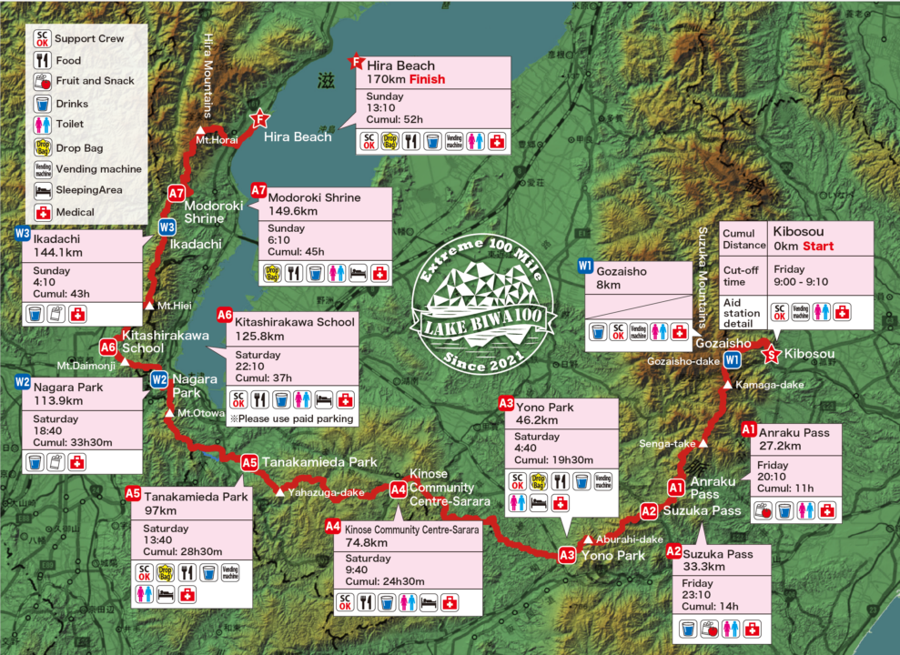
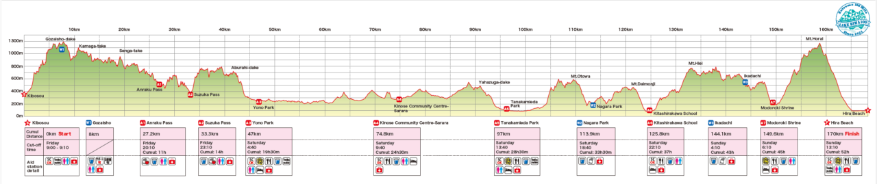
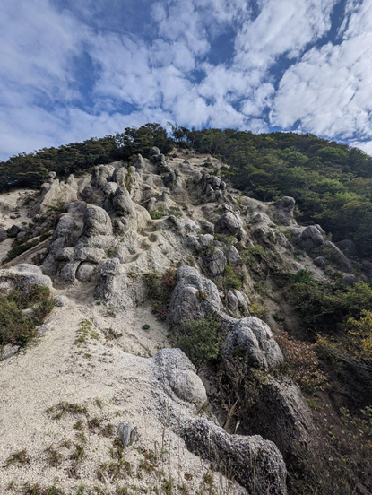
The mountains surrounding Lake Biwa rewards participants with various and exciting challenges, as well as beautiful scenery along the course. The course starts with the rough mountainous area in Suzuka Mountains, climbing up Mt. Gozaisho, the highest peak of the race at 1212m. After navigating the technical Suzuka range, runners enter Shiga Prefecture on the Tokai Nature, a relatively flat section.
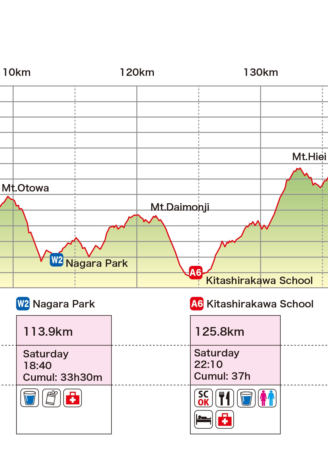
Not too long after the A5 Aid Station and after passing the 100k mark comes a series of mountains that are not too high, but pack steep ascents and descents. After a respite at A6 comes the long climb to the famous Mt. Hiei Enryakuji Temple. After conquering this mountainous area with many roots, the runner reaches the last aid station located at Modoroki Shrine, where runners can pray for their safe return and finish.
The last challenge is the long steep ascent of the Hira mountain range to the ridgeline, reaching the course’s second highest peak, Mt Horai. The views of Lake Biwa from the ridgeline are amongst, if not, the best in the whole journey. Then, the final 1000m steep descent to Lake Biwa will test your knees, before running the last few kilometers along the beach until the finish. After passing the finish line, many runners dive in the lake in celebration.
The Cut-off time is relatively generous, but the course is challenging. Since completing this course itself is a big challenge, this race is sometimes a first step for local runners aiming at entering overseas races. For overseas runners, this is a unique opportunity to experience the beautiful nature of Japan, steep and challenging mountains, and Japanese culture.
Distance 170km D+10,500m
IBUKI publishes and distributes the GPX file. Please make sure to check the details of the route before the race and download the GPX file to your mobile phone and your GPS watch.
IBUKI event page (Each aid station is plotted on this map.)
※ The distance and the elevation may be stated smaller than actual number because of its algorithm.
目次
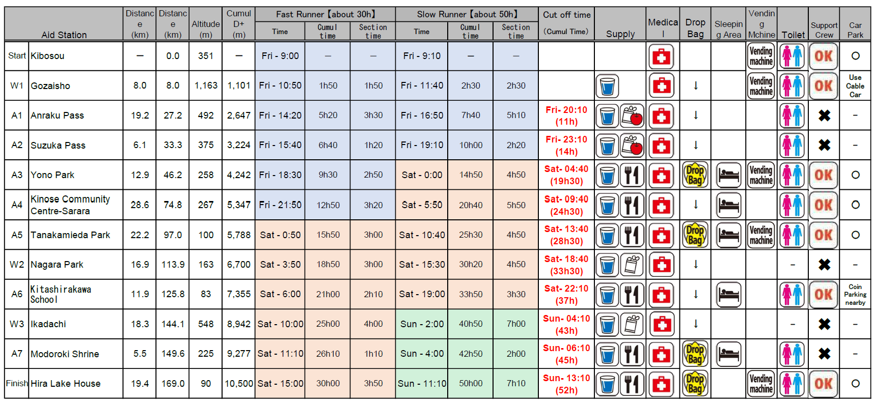
- ①Start(Kibosou)0km~A1(Anraku Pass)27.2km A1 Cut off time 11h(Fri- 20:10)
- ②A1(Anraku Pass)27.2km~A2(Suzuka Pass)33.3km A2 Cut off time 14h(Fri- 23:10)
- ③A2(Suzuka Pass)33.3km~A3(Yono Park)46.2km A3 Cut off time 19h30(Sat- 4:40)
- ④A3(Yono Park)46.2km~A4(Kinose Community Centre-Sarara)74.8km
A4 Cut off time 24h30(Sat- 9:40) - ⑤A4(Kinose Community Centre-Sarara)74.8km~A5(Tanakamieda Park)97km
A5 Cut off time 28h30(Sat- 13:40) - ⑥A5(Tanakamieda Park)97km~W2(Nagara Park)113.9km
W2 Cut off time 33h30(Sat- 18:40) - ⑦W2(Nagara Park)113.9km~A6(Kitashirakawa School)125.8km
A6 Cut off time 37h(Sat- 22:10) - ⑧A6(Kitashirakawa School)125.8km~A7(Modoroki Shrine)149.6km
A7 Cut off time 45h(Sun- 6:10) - ⑨A7(Modoroki Shrine)149.6km~Finish(Carmel Beach Club)170km
Finish Cut off time 52h(Sun- 13:10) - Restrictions
①Start(Kibosou)0km~A1(Anraku Pass)27.2km A1 Cut off time 11h(Fri- 20:10)
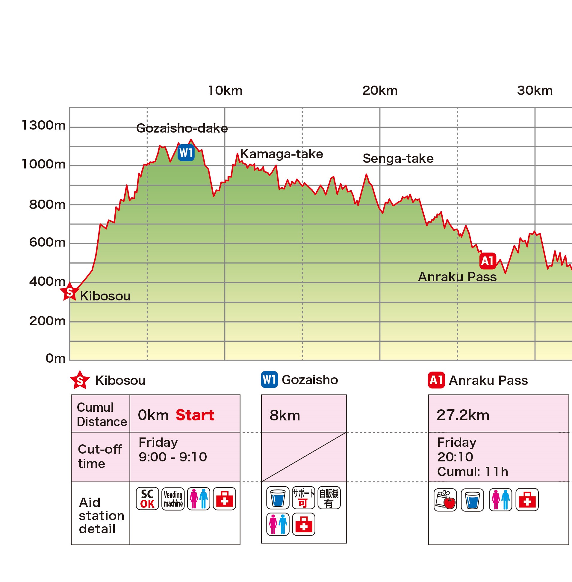
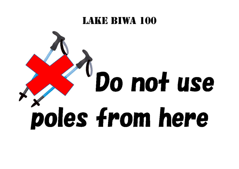
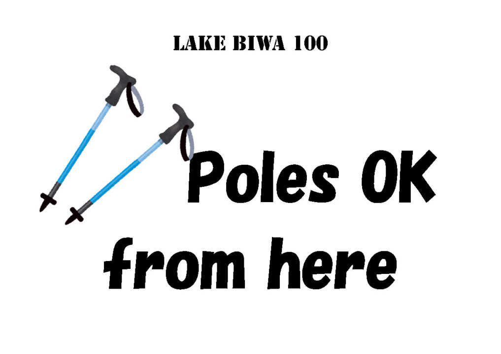
・The 9 km section from Buna Shimizu (5 km) to Iwakura Ridge Branch (14 km) is a special nature reserve of the quasi-national park and poles cannot be used and runners are advised to go slow. This area is quite popular with hikers, so please walk when passing them.
Signs are placed at the beginning and end of this section, so please follow the signs.
・Make sure to pass the peak of Mt Gozaisho.
・Water aid station, vending machines and toilets are available at Mt. Gozaisho.
・Please place a high priority on giving a way to hikers around Mt Gozaisho.
・Support Crew can access to the water aid station at Mt. Gozaisho by the Gozaisho cable car
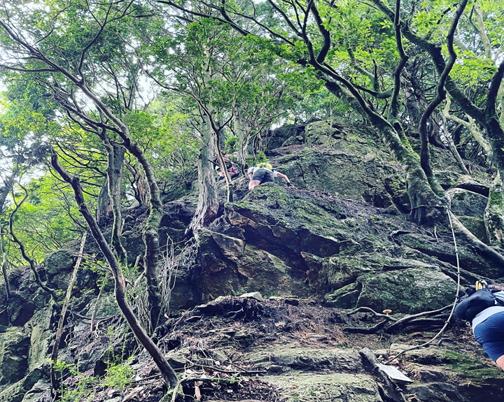
・Be careful especially after the ascent of Mt Kamagatake. There are many technical places (using chains or scrambling) to ascent and descend.
・Be prepared to use your head lights after Mt. Sengatake because it gets dark between Mt. Sengatake and Anraku Pass for the most of runners.
・Personal assistance or watching runners at A1 Anraku Pass is prohibited due to lack of parking space.
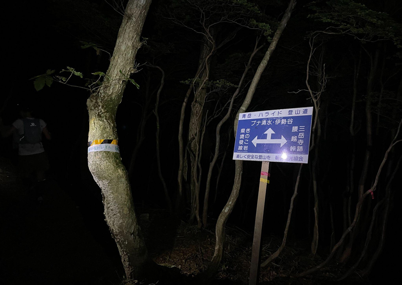
This is a rugged area, so watch out your steps and course markings!
②A1(Anraku Pass)27.2km~A2(Suzuka Pass)33.3km A2 Cut off time 14h(Fri- 23:10)
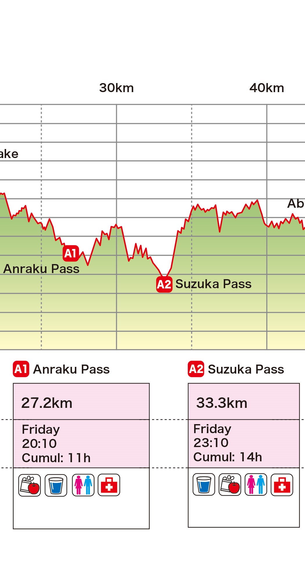
- The steep climb immediately after the Anraku Pass is a rocky, narrow ridge and there is a risk of falling rocks. Keep a sufficient distance between you and the runner in front and behind you, and if you let a rock fall, shout loudly to inform the runners behind you.
- Watch out the continuous narrow ridges after Mt. Shiosoyama. If you miss a step, there is a big risk of slipping and falling. Special attention and concentration is important.
The distance is short, but the section takes time. Don’t let your guard down just because the distance is short, and make sure you have plenty of drink.
③A2(Suzuka Pass)33.3km~A3(Yono Park)46.2km A3 Cut off time 19h30(Sat- 4:40)
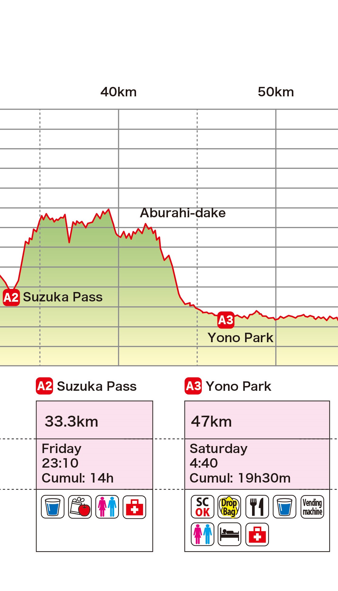
- Pay extra attention due to technical sections with chains and ropes.
- Run carefully on narrow ridges.
- Drop bag and sleeping area is available at A3 (put a sleeping bag, etc. in your drop bag should you need to sleep). Many runners don’t plan on sleeping here, but end up napping due to tiredness.
This section takes longer than you think, so keep your concentration and carry plenty of drinks! Danger of slipping and falling! Japanese curry is available at A3 (not so spicy)
Watch out for falling rocks. Also, the use of ropes can be dangerous if several people hold onto the same rope, so keep a reasonable distance between them and tell the person following you when you have grabbed the next rope.
④A3(Yono Park)46.2km~A4(Kinose Community Centre-Sarara)74.8km
A4 Cut off time 24h30(Sat- 9:40)
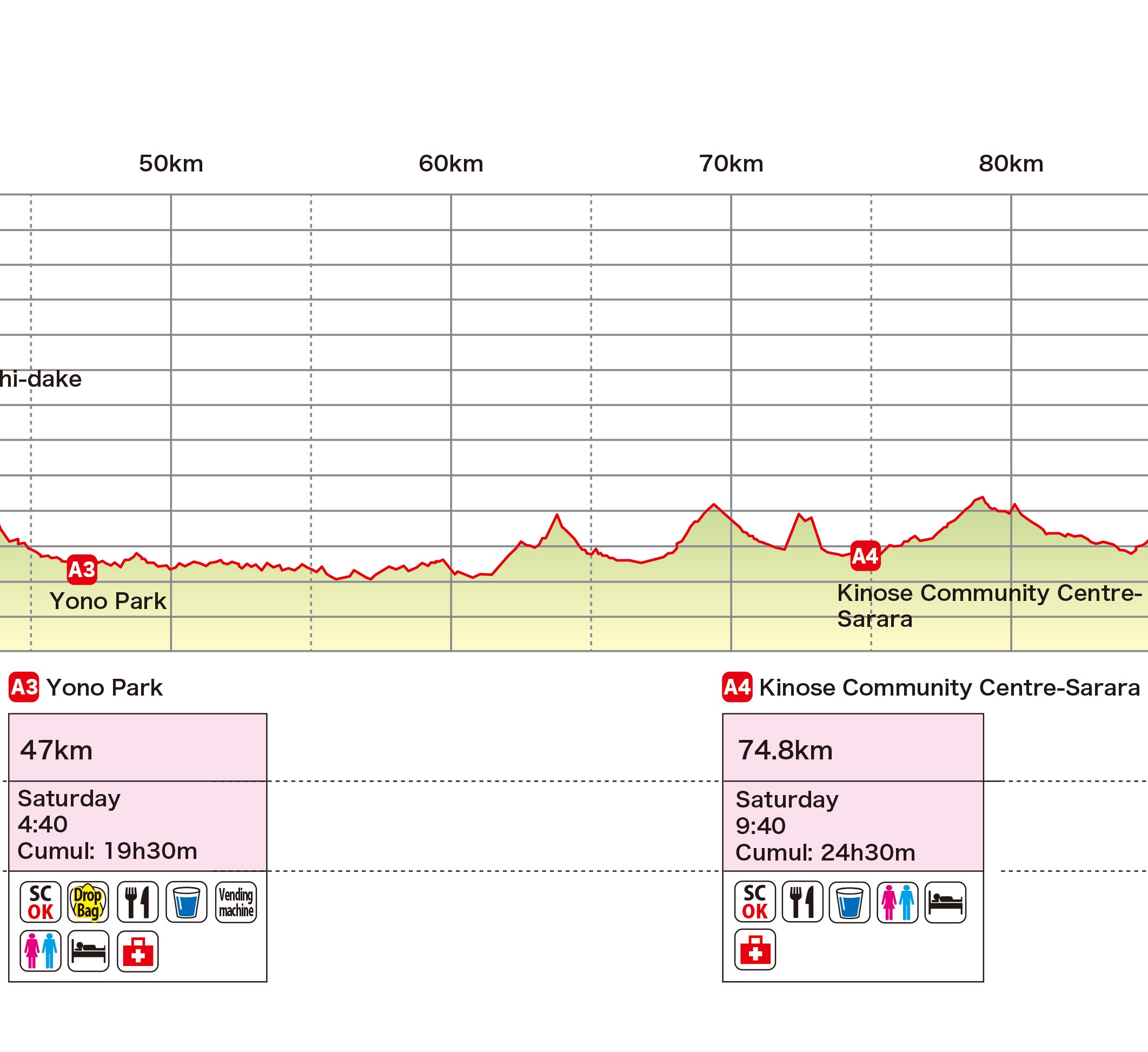
- Mostly runnable section with asphalt roads, forest trails and small peaks, following the Tokai Shizen Hodo signs (Tokai Nature Trail, 東海自然歩道 in Kanji).
- Follow traffic rules and pay close attention to vehicles when crossing roads.
- When passing through residential areas, take care not to disturb residents with noise like conversations, bear bells, etc..
- There are three animal gates, and staff should be in attendance to open and close the gates for runners. However, if no staff is seen around the gates for some reason, make sure to close the gates properly after passing through.
- The trail before Shigarakigushi station is quite damaged and there is big ditch, so try not to run in the ditch. There is a footpath on the side of the ditch.
- Do not forget to exchange the IBUKI tracking device to a new one at A4!
This is a bit complicating route, so be careful not to get lost. This is runnable section! Oyako-don (Japanese style chicken and egg rice bowl) is waiting for you! Warm sleeping rooms are available.
⑤A4(Kinose Community Centre-Sarara)74.8km~A5(Tanakamieda Park)97km
A5 Cut off time 28h30(Sat- 13:40)
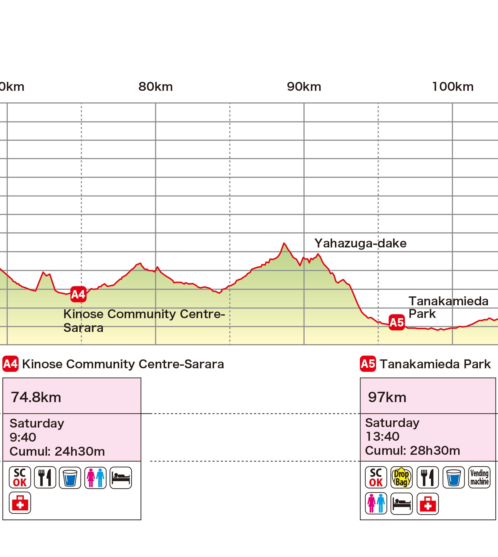
- Mostly runnable section with asphalt roads, forest trails and small peaks following the Tokai Shizen Hodo signs (Tokai Nature Trail, 東海自然歩道 in Kanji).
- Follow traffic rules and pay close attention to vehicles when crossing roads.
- When passing through residential areas, take care not to disturb residents with noise like conversations, bear bells, etc..
- Please be careful when you go down from Mt. Yahazudake. The route goes through a wet cascade which is very slippery even on sunny days.
- Drop bag and sleeping area is available at A5 (put a sleeping bag, etc. in your drop bag should you need to sleep). Many runners don’t plan on sleeping here, but end up napping due to tiredness.
This wet rocky area is very slippery!
This is also a runnable section! Tonjiru (Japanese style pork and vegetable miso soup) is available at A5!
⑥A5(Tanakamieda Park)97km~W2(Nagara Park)113.9km
W2 Cut off time 33h30(Sat- 18:40)
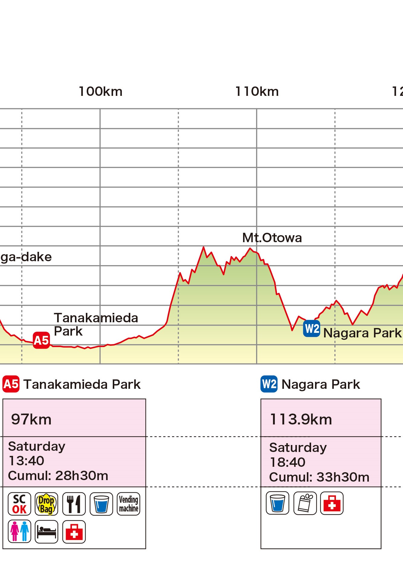
- The 5km road section from Tanakamieda Park to the Ohirayama trailhead passes through villages, residential areas, parks and fields in a complex way, so make sure to check your GPS watch or mobile phone to navigate correctly.
- Follow traffic rules and pay close attention to vehicles when crossing roads.
- When passing through residential areas, take care not to disturb residents with noise like conversations, bear bells, etc..
- The route from Mt Ohira to the descent of Mt Otowa is a series of ups and downs, but you can enjoy the view of Lake Biwa from between the trees.
- W1 Nagara parc provides only drinks, Japanese sweets, Calorie-Mate blocks and gels. No hot food.
This section is harder than you expect with steep climbs. W1 is stated as a water aid, but Japanese sweets (Asuka Foods) and Calorie Mate and Jelly (Otsuka Pharmaceutical) are also provided!
⑦W2(Nagara Park)113.9km~A6(Kitashirakawa School)125.8km
A6 Cut off time 37h(Sat- 22:10)
- Do not use a bear bell or talk loudly after the descent of Mt Daimonji to A6 Kitashirakawa aid station and to the next trailhead, especially at night and early morning, because it’s a residential area.
- Mt. Daimonji is a popular mountain with many hikers during the day. Give priority to hikers, walk when passing or overtaking, and do not run through the side of them. Make sure the hikers are aware of your presence by talking to them.
- Follow traffic rules and pay close attention to vehicles when crossing roads.
- A6 Kitashirakawa Primary School doesn’t have a car parking, so if your crew wishes to support you, have them use the nearby coin-operated parking and walk to the aid station. Street parking is strictly prohibited!
- Keep quiet at night and early in the morning.
- Support crews have to show their support crew bib to enter the aid station. Supporters without crew bibs may not enter the primary school grounds.
Every year some local hikers remove course markings around Mt. Daimonji, so please check your GPS watch or offline map to navigate through. Special Udon noodles are provided at A6!
⑧A6(Kitashirakawa School)125.8km~A7(Modoroki Shrine)149.6km
A7 Cut off time 45h(Sun- 6:10)
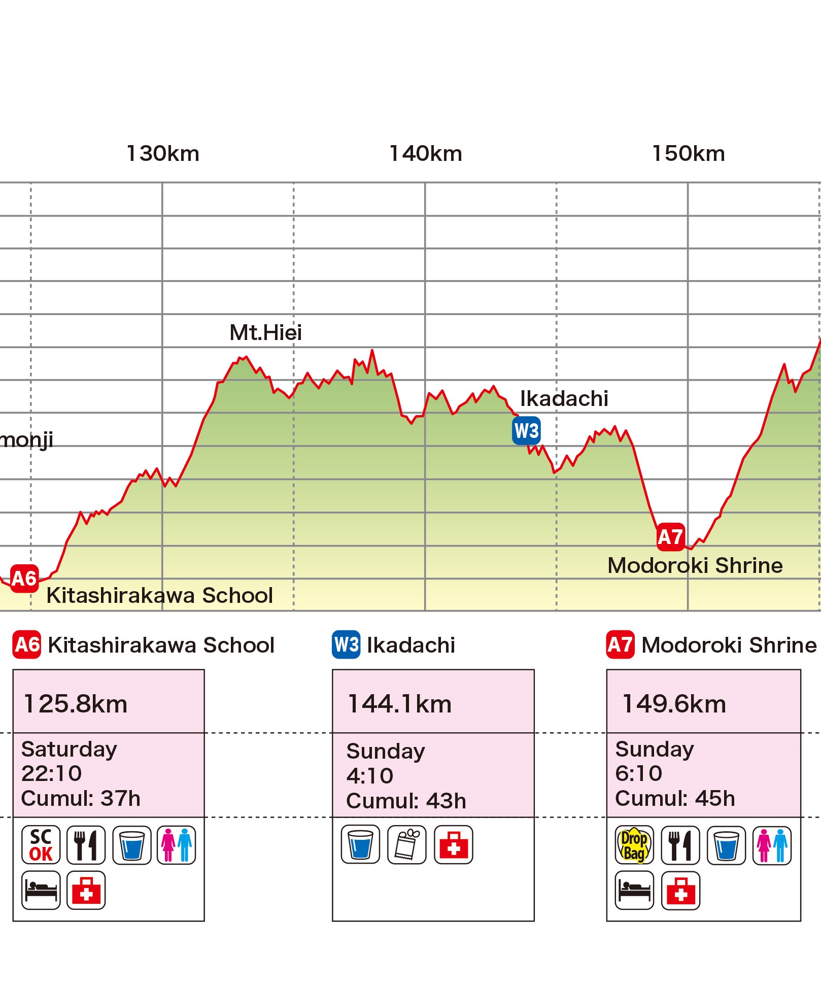
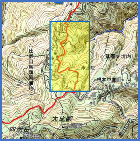
- The section from the bridge just before entering Enryakuji temple area to the next trailhead is a slow down zone (indicated by signposts on the course). Bear bells are also prohibited in this section.
- The course of the Hira Hiei Trail (yellow marking tapes with Japanese writing on) and the LAKEBIWA100 is exactly the same from the Oogi Pass to A7 Modoroki Shrine
- Drop bag and sleeping area is available at A7 (put a sleeping bag, etc. in your drop bag should you need to sleep). Many runners don’t plan on sleeping here, but end up napping due to tiredness.
Mt Hiei is also a popular mountain with day trippers. In 2022 and 2024, someone took the course markings off and put them in the wrong places to mislead runners, so make sure to check your GPS watch or offline map. Carry enough water as this section is very time consuming. There will be a water aid station at 18.3km from A6, but even getting there will take time. Many past runners call this section “the infinite loop”. Egg and rice soup is waiting for you at A7!
⑨A7(Modoroki Shrine)149.6km~Finish(Carmel Beach Club)170km
Finish Cut off time 52h(Sun- 13:10)

- Towards Mt. Horai there are three peaks with steep climbs. Very tough section.
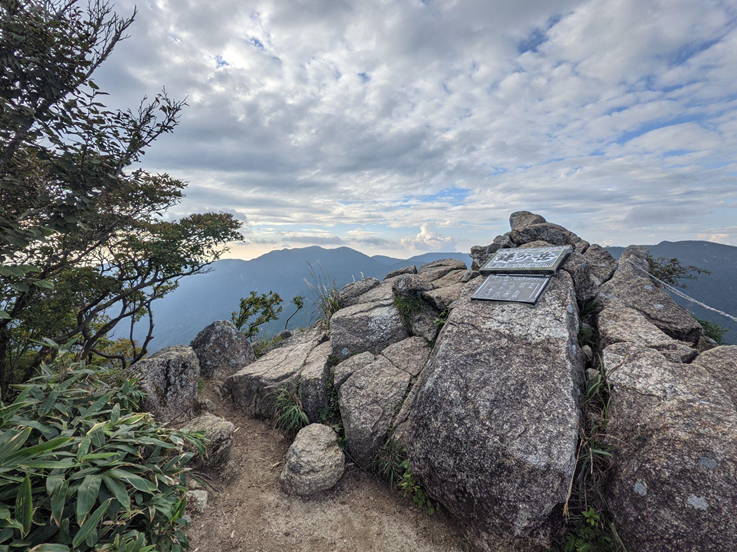
- Enjoy great views of Lake Biwa from Mount Horai. You can see all the mountains you have run so far on a clear day.
- Be careful not to miss the entrance to the rugged descent before the Biwako Valley Ropeway on Mt. Uchimi after Mt.Horai.
- After descending Mt. Uchimi, enjoy the last 5km run along the Lake Biwa shore.
- Ensure that the bear bell does not ring once you are on the asphalt road.
- Stay quiet on the asphalt road after descending from the last mountain and around the finish line at night and early in the morning, even if you are so excited to finish the race. We have to respect the residents around us.
The last major climb has three stages: Mt Ryosen, Mt Gongen and Mt Horai. It is very long and time-consuming, so make sure you have plenty of water. The descent is also very long, so buying drinks at the vending machines at Biwako Valley Ski Resort after Mt Horai is strongly recommended. Enjoy the spectacular view looking back from the mountain top and dive into Lake Biwa!
Restrictions
Slow down area・Running poles prohibited area
Please go slow in the following areas
- Suzuka quasi-national park special reserved area: It will be marked on the course (approx. kilometers 5 to 14) ※except for the ASPHALT-PAVED ROAD and the ski slope
- In the Mt. Hiei Enryakuji temple: It will be marked on the course (approx. kilometers 134 to 135)
Please do not use poles in the following area
- Suzuka quasi-national park special reserved area: It will be marked on the course (approx. kilometers 5 to 14) ※except for the ASPHALT-PAVED ROAD and the ski slope
Personal Assistance
Personal assistance is accepted at the following aid stations:
W1, A3, A4, A5, A6*
*A6 does not have car parking. Please use coin parkings nearby and do not park on the street.
Assistance outside aid stations is prohibited.
Pacers are not allowed on course, though your crew and family may run the last few kilometers to the finish with you.
Restrictions at aid stations
- Only one support crew is allowed to enter each aid station and support bags should not exceed 40 liters.
- Please be quiet at the aid stations in residential area at night.
Use of shops and vending machines on the course
Use of shops and vending machines on the course is allowed. If you go off course for any reason (drinks, views, etc.), you must go back to the point where you left the course before proceeding.
Failure to respect the rules and restrictions of the race by either racer or support crew will result in penalties at the discretion of the Organizing Committee, reaching disqualification in severe cases.